Saturday, April 26, 2014

Our Future

Many people, including myself might be wondering what the future holds for our climate.  Is global warming worsening or are we moving into the next ice age?  First, we must look at the definitions of weather and climate to further understand this topic.  "Weather is what conditions of the atmosphere are, over a short period of time.  Climate is how the atmosphere "behaves" over relatively long periods of time." www.nasa.gov/mission_pages/hoaa.../climate/climate_weather.htm
 
If the weather during the winter of 2014 was an indication of the future, then I would say that we are moving into the next ice age.  The below zero temperatures combined with the amount of snow that many parts of the country experienced was phenomenal.  But this was our weather conditions over a short period of time.  We really need to look at the climate to predict what the future holds.  This is not going to be an easy task due to global warming.  The definition of global warming is "an unusually rapid increase in Earth's average surface temperature over the past century primarily due to greenhouse gases released by people burning fossil fuels." http://earthobservatory.nasa.gov/Features/GlobalWarming/
  
A mathematician named Milankovitch has an astronomical theory.  His theory of climate change is an explanation for changes in the seasons which result from changes in the earth's orbit around the sun. There is solar variable, eccentricity (shape of orbit), obliquity (tilt-which causes the seasons and the changes in the tilt of the earth change the strength of the seasons) and precession (wobble).  As the earth travels through space, three separate cycle movements combine to produce variations in the amount of solar energy falling.  It is believed that Milankovitch's theory does not allow the prediction of a "rapid" ice age onset.  Milankovitch's prediction is less than a century or two.  http://www.ncolc.noaa.gov/paleo/milankovitch.html
 
The greenhouse effect is worsening by the increased levels of carbon dioxide being countered by low-level clouds that are created by dust and other contaminants.  Scientists are having difficulty predicting what the overall climatic results will be as long as humans continue to pollute the earth, and global warming continues.  http://en.wikipedia.org/wiki/Global_cooling
 
A newspaper article states that "our own interglacial period has followed previous ones in having an abrupt beginning and a sharp peak, followed by slow cooling".  It states that there is question as to whether mankind's negative impact on the atmosphere has reversed the cooling course. 
 
I feel that at this time, the next ice age may be considered late coming.  Humankind's impact has had a significant change on our climate.  We need to be more conscious of how we lead our daily lives with respect to our environment.  If we continue to pollute our earth with greenhouse gases, the greenhouse concentration will continue to rise and the earth's surface temperature will continue to rise also.  If we can't control global warming, then the next ice age may be late. 
 
 
Greenhouse Effect


Melting Sea Ice
The Horrible Effects of Global Warming


Carbon Dioxide and other pollutants entering the atmosphere
causing the greenhouse effect.


Friday, April 18, 2014

Mink Lake is a kettle lake!

I wanted to visit a kettle lake in the Calumet Region.  A kettle lake is formed when large blocks of glacial ice close to the edge of a glacier break away from the main mass.  The blocks of ice are then buried by till or outwash (sand and gravel set down by the water from the melting glacier).  The block of ice that is buried eventually thaws and the sediment on top breaks down and a large hole will develop.  If the block of ice is rather large, than the hole will be larger.  The hole is filled with water and is then considered to be a kettle lake.  Kettle lakes are deep and are named after the black kettles with the rounded bottoms that the settlers had used.  (Schoon, pg. 23)
 
During my research of kettle lakes in the Calumet Region, I discovered that the Valparaiso Moraine has small kettle lakes upon it.  The Lake Michigan ice lobe deposited the Valparaiso moraine in a wide curve across far northwestern IN.  Along the moraine, the kettle lakes developed.  These water filled kettle shaped depressions are scattered along the moraine.  They were created by the melting of partially buried very large blocks of ice.  http://faculty.pnc.edu/pwilkin/geology.html  
 
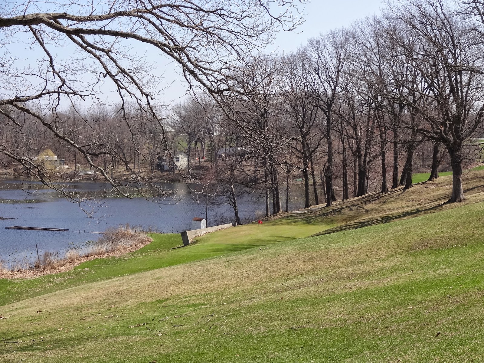
Mink Lake is one of the kettle lakes on the Valparaiso Moraine.  It is located north of the Valparaiso city limits and west of Rt. 49.  I traveled there and found it located near the intersection of North Calumet Ave. and 632N/638N.  The lake is surrounded by a hilly golf course and a campground. 
Travelers can enjoy the golf course, fishing at the lake or staying at the campground.  There is also a bog (a small marsh) that you can visit called Hotter Lagoon next to Mink Lake.  http://www.valpolife.com
 
It is a pretty area to visit.  There are homes across the street from the lake, up on a hill.  Since studying about the glacial history in the Calumet Region, it makes me wonder if the neighbors there are aware of the lake's history.  It does give you a new found appreciation for our geology in the region.  When you think that this all started with the ice age and that it created such a beautiful landscape, it makes you feel very inspired!
 
References: Kenneth J. Schoon/Calumet Beginnings
 
Mink Lake which sits on the Valparaiso Moraine is
a kettle lake.
 
Photograph Taken By: Carol Haynes
 
 
Mink Lake is surrounded by a hilly golf course and
a campground.
 
Photograph Taken By: Carol Haynes
 
Ducks on the shoreline of Mink Lake.
 
Photograph Taken By: Carol Haynes
 
Mink Lake is off the intersection of 632N/638N/N. Calumet Ave.
Valparaiso, IN
 
Photograph Taken By: Carol Haynes


The Valparaiso Moraine

During my travels of the Calumet Region, I wanted to visit a moraine.  A moraine is "a geographical feature composed of materials that were deposited by a glacier". (Schoon pg. 221) In my class, Groundwater and Glaciers, I read about the Valparaiso Moraine. 
 
The moraine was created during the Pleistocene ice age, 1.8 million to 11,000 years ago.  The deposit or till contains small and large particles.  These particles can be clay, silt, sand, gravel pebbles and boulders.  When the ice age came to an end, the glaciers retreated north and vegetation started to develop.  (http://faculty.pnc.edu/pwilkin/geology.html/
 
The Valparaiso Moraine is about 60 miles long in Indiana and between 5 and 15 miles wide.  The Lake Michigan ice lobe set down the Valparaiso Moraine in a large curve across far northwestern Indiana. To the north, the moraine impounded a lake along the edge of the ice lobe, which was melting.  Mixed till and outwash were left from the meltwaters that had overflowed in places.  Kettle lakes ("a depression left where a block of ice, left behind in glacial sediments, finally melted") are also found in the region.  (Camp/Graham pg. 226, 296)
 
While researching the Valparaiso Moraine, I discovered an area that I could visit. 
I traveled east on Rt. 30 into Valparaiso.  I came to the intersection of N. Calumet Ave. and 632N/638N.  As I approached this area, I could see Mink Lake (which is a kettle lake) situated on part of the Valparaiso moraine.  A very hilly golf course rested around the lake.  As I stood and looked over the golf course and the lake, I was amazed that this was a part of the region's geological history. 
 
References: Kenneth J. Schoon/Calumet Beginnings
Mark J. Camp, Graham T. Richardson/Roadside Geology of Indiana


A part of the Valparaiso Moraine was used to create
a rolling hill golf course.
 
Photograph Taken By: Carol Haynes
 

A kettle lake called Mink Lake is located on the
Valparaiso Moraine.
 
Photograph Taken By: Carol Haynes

A campground sits on the Valparaiso Moraine across
from Mink Lake.
 
Photograph Taken By: Carol Haynes


Thursday, April 17, 2014

Calumet Human Impacts

The Calumet Region is rich in history.  The Region was shaped by glaciers. The glaciers receded and formed the shorelines of Lake Michigan.  The population of the Region started with settlers that came from the south and east during the 1830's. 
 
The Native Americans were the first to arrive followed by the French Explorers, and then the British. In the early days, the land was difficult to travel upon. It consisted of marshlands and wide flood plains. The shorelines turned into sandy highways which connected the east and the west. This was the high ground that the stagecoaches traveled upon. Stagecoaches traveled the Region in the 1830's but the railroads took over in the 1850's. The railroads brought wealth to the Region and employed hundreds of residents. (Schoon, pg. 45)
 
The Railways changed the shape of the landscape in the Region.  Also, logging changed the look of sections in Hammond.  The moraines and sand ridges at one time were forested. Also, sand mining became popular by scraping sand from the tops of the ridge.  The farmers then built their homes after the sand removal.  The sand was used to fill in nearby marshlands.  Wholesale sand mining contributed to the biggest change in the landscape.  (Schoon pgs. 96, 97)
 
Since the 1960's the development of residential neighborhoods in the Calumet Region has changed.  In the past, neighborhoods were created on land that was leveled off and the wetlands were eliminated.  It has become popular to develop neighborhoods on natural slopes and have included water in their landscapes.  Lakes of the Four Seasons, was the first of the developments to create their landscape in this manner.  (Schoon, pg. 102)
 
Lake Michigan is a highly valued  resource because of its' use for recreation, the dependence upon it from the nearby industries for travel and as a water source for the Region.  Industries that have been attracted to the Region are brickmaking, steel mills, oil refineries, lead foundries and gravel and stone mining. 
 
The Calumet Area is also known for its' prairies, bogs, fens, lakes, hills and lowlands.  We must do everything that we can to protect and preserve these areas.  They are habitats for ducks, wading birds, shorebirds, beavers, vegetation, sedges and flowering plants to name a few. http://en.wikipedia.org/wiki/Habitats-of_the_Indiana_Dunes
 
 
The Calumet Region has evolved over the past hundreds of years.  It's landscape has changed due to natural causes but also due to man made creations.  The industries that have been built up over the years have provided resources for America and jobs for its' residents.  The downside is that these same industries have been responsible for a great deal of water pollution in the rivers and in the lakes of the Calumet Area. 
 
We, as residents must do our part in preserving the beauty of the Calumet Region.  When you look at its' history, we need to value how the Region became what it is today and to protect and preserve the natural habitats and environment. 
 
References: 
E.C. Pielou/Fresh Water
Kenneth J. Schoon/Calumet Beginnings
 
Inland Steel, now known as Arcelor Mittal Steel.  It is located
on Lake Michigan in the Indiana Harbor of East Chicago.


Lakes of the Four Seasons, IN
Located on the border of Lake County and Porter County
 
 
BP Oil Refinery spill along Lake Michigan in Whiting IN.
 
Reference: g.com/images/search?q=bp+whiting+indiana


Saturday, April 5, 2014

The Calumet River

I have lived in the Calumet Region my entire life, but I didn't really know the history behind the Calumet River.  I drive by the Little Calumet River everyday on my way to work, and thought that this would be an interesting subject to research.
 
The Grand and Little Calumet Rivers flow between the ancient shorelines and Lake Michigan. 
Over thousands of years The Calumet Region and The Calumet River have shown changes due to ice retreat, declines in the levels of Lake Michigan, industrialization and settlement.  (Schoon pg. 39)
 
When the glacier retreated from the Calumet Area and Lake Michigan was formed, the Calumet River was created in Western LaPorte County.  It flowed northwestward, carrying ground and rain waters.  It emptied into the lake south of where Michigan City is today.  The lake level receded about 2500 years ago and due to this the Calumet River then took a turn south of what we know now as Blue Island.  (Schoon, pg.40)
 
The sands began to force the mouth 22 miles eastward, going past what we know now as Riverdale, Hegewisch, Hammond and Miller Beach.  Today the Grand Calumet River flows westward.  It flows from Marquette Park Lagoon to the junction with the Calumet River at Hegewisch. (Schoon pg. 40)
 
The Calumet River is 13 miles long.  Over the course of geological history, the landscape of The Calumet River has been created.  Wind erosion and lake recession have created dune and ecosystems.  Hydrology and climate have helped create the wetlands, savannas, prairies and forests. 
 
The destruction of the habitats that we see today is not due to glacial ice but to industrial and urban development.  The introduction of non-native invasive species have also contributed to the habitats' destruction.  http://www.indianaacademyofscience.org/Documents/Proceedings
 
Due to the Calumet River's flat gradient, much of the Little Calumet River has always been flood prone. (Schoon, pg. 42) Unfortunately many people in the Calumet Region have witnessed how tragic this type of flood can be. 
 
References: Kenneth J. Schoon, Calumet Beginnings
 
Picture of The Little Calumet River in Highland. This portion of the river has
had a lot of work done to it for flood control purposes.
 
Photograph Taken By:  Carol Haynes
 
 
The Little Calumet River flows under a walking bridge
that leads to a nature trail.
 
Photograph Taken By:  Carol Haynes
 
 
The walking bridge that goes over the Little Calumet River
is fairly new.  The nature trail on the other side connects with
Oxbow Park in the Hessville side of Hammond.  This area is on the north
side of the river.
 
Reference:  Daniel Haynes (former resident of Highland)
 
Photograph Taken By:  Carol Haynes
 
 
Along the bank of this river was the Highland dump.  They
have since closed it down and the river has become
more scenic. 
 
Reference:  Daniel Haynes (former resident of Highland)
 
Photograph Taken By:  Carol Haynes